Contrary to the common view of Quebec’s fortifications as a simple historic wall, they are a readable text of evolving military doctrine, where every angle and bastion tells a story of strategic intent.
- The star-shaped Citadel was not just for defence against external attack but also a tool of internal control, a paradox built in stone.
- A self-guided tour can be a tactical exercise, allowing you to identify key fields of fire and defensive layers that standard tours often miss.
Recommendation: Approach your visit not as a tourist walking a wall, but as a historian deciphering a strategic manuscript, focusing on the ‘why’ behind each architectural feature.
For any history enthusiast, standing before the fortifications of Quebec City is a moment of profound connection to the past. The sheer scale of the ramparts, the stoic presence of the cannons, and the palpable sense of history are undeniable. Many visitors content themselves with a leisurely stroll along the 4.6 kilometres of walls, capturing photographs of the stunning vistas over the St. Lawrence River and the historic old town. This experience, while pleasant, only scratches the surface of the profound story embedded in the limestone and mortar.
Standard tourist guides often point out the main gates and offer anecdotes, but they rarely delve into the military science that shaped this monumental structure. They treat the fortifications as a static backdrop for the city, rather than the dynamic, evolving protagonist in its history. The true narrative lies not just in what was built, but why it was built in a specific way. It’s a story of shifting empires, technological arms races, and the complex geopolitics of North America.
But what if the key to truly understanding the fortifications was not just to walk them, but to learn how to read them? This guide departs from the conventional tour. We will adopt the perspective of a military historian, decoding the defensive doctrines that dictated the design of the Citadel and the ramparts. We will analyze the strategic paradoxes of their construction and explore how this military heritage continues to shape the city’s identity and even its real estate market today.
This article will guide you through the layers of military strategy etched into Quebec’s walls. We will examine the revolutionary design of the Citadel, offer a tactical itinerary for a short but insightful visit, and weigh the merits of guided tours versus solo exploration. By the end, you will see the fortifications not merely as old walls, but as a masterclass in military architecture waiting to be understood.
Summary: Walking the Walls: A Strategic Guide to Quebec City’s Fortifications for History Buffs
- Why the star-shaped Citadel design was revolutionary in the 1800s
- How to tour the fortifications in under 2 hours without missing key cannons
- Parks Canada guided tour vs. Solo walk: Which offers better historical insight?
- The silent erosion attacking the limestone walls and what it costs taxpayers
- When to catch the Changing of the Guard: avoiding the summer crowds
- Beyond the cannons: Finding the exact spot where Wolfe fell
- Guided tour vs. History books: Is the paid visit inside worth the $25?
- The Plains of Abraham: Best Spots for Picnics, History, and Sports
Why the star-shaped Citadel design was revolutionary in the 1800s
The star-shaped fortress, or *trace italienne*, was not a new concept in the 19th century, but its application at Quebec’s Citadel represented the pinnacle of a defensive doctrine perfected over 300 years. The design’s genius lay in its solution to the single greatest threat to medieval walls: cannon fire. By angling the walls into sharp, protruding bastions, it eliminated “dead zones” where attackers could shelter. Every inch of ground before the wall was covered by overlapping fields of fire from cannons and muskets on the ramparts. The low, thick, sloping walls were far more effective at deflecting or absorbing cannonballs than the tall, vertical walls of earlier castles.
The Citadel’s design, initiated by the British after 1759 and largely completed between 1820 and 1831, was a masterclass in this principle. With its approximately 300 cannon pieces in place by the 1830s, it created a formidable killing ground for any approaching army. However, the true revolutionary aspect of its design in the Quebec context was not just its geometry, but its orientation. It revealed a fascinating strategic paradox at the heart of British military thinking in Lower Canada.
The British Strategic Paradox
A close analysis of the Citadel’s layout reveals a telling detail. The most heavily armed and modern fronts were not those facing a potential American invasion from the south, but those facing the city of Quebec itself. This indicates that the Citadel was conceived with a dual purpose: to defend the city from external enemies and to serve as a secure redoubt for the British garrison in the event of a Francophone uprising from within. It was as much a tool of colonial control as it was a bulwark against foreign powers, a political statement written in stone.
This dual-purpose design made the Citadel a complex and sophisticated instrument of power. It wasn’t just a shield; it was a mechanism to project authority, capable of defending against an invading army while simultaneously intimidating the local populace. Understanding this paradox is the first step to reading the walls as a text of political and military intent, not just a defensive structure.
How to tour the fortifications in under 2 hours without missing key cannons
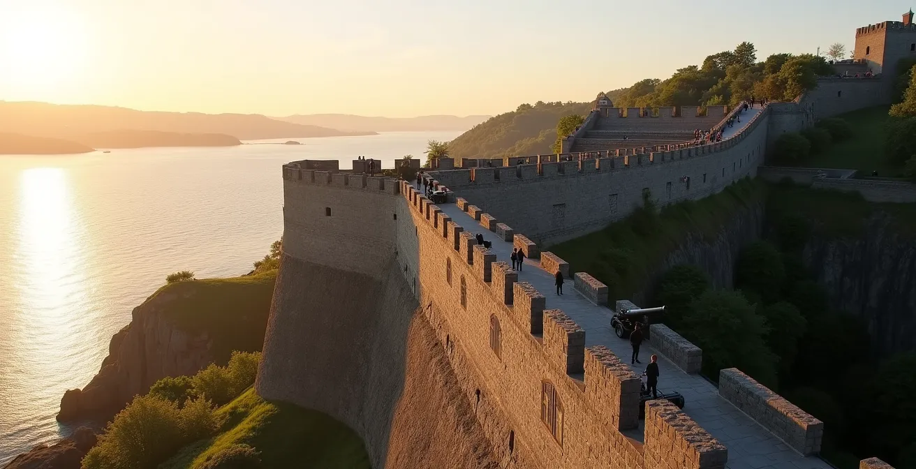
A comprehensive exploration of the fortifications can take a full day, but for the time-conscious history buff, a focused two-hour walk can yield significant insights. The key is to approach it not as a scenic stroll, but as a tactical itinerary designed to reveal the logic of the defensive system. The goal is to identify the key firing positions, understand the layering of defences, and appreciate the strategic vistas that the original military engineers prized.
This route focuses on the southern and western ramparts, which offer the best-preserved features and the most critical defensive viewpoints. Instead of simply walking, you will be actively looking for specific architectural clues: the splaying of an embrasure (the opening for a cannon) to maximize its arc of fire, the placement of bastions to create interlocking fields of fire, and the sightlines a cannon commander would have had over the St. Lawrence River and the Plains of Abraham.

As the image above illustrates, the cannons were not placed randomly. Each one was sighted to cover a specific sector, often overlapping with its neighbours to ensure no enemy vessel or infantry unit could approach unmolested. Your walk should be a quest to spot these carefully planned positions and imagine the coordinated defensive web they formed. This active observation transforms a simple walk into an analytical exercise.
Your Strategic Defender’s 2-Hour Walking Route
- Start at Porte Saint-Jean: Climb the stairs to the top of the rampart. Take a moment to observe the panoramic view landward, imagining how these walls would dominate the approach to the city.
- Walk South towards the Citadel: This stretch provides the best vantage points over the St. Lawrence. Stop at the cannon positions and note how they are aimed to cover the main shipping channel, the primary invasion route for centuries.
- Observe Key Embrasures: Look for cannons positioned to provide enfilading fire along the face of the next bastion. This is a classic element of the star-fort design.
- Continue to Porte Kent: This section demonstrates the landward defensive strategy. Note how the walls are designed to defend against an army approaching from the Plains of Abraham.
- Complete the Circuit View: As you walk, look for surviving embrasures, firing steps for musketeers, and the thickness of the earth-backed walls, all testament to a design built to withstand artillery.
By following this focused itinerary, you can gain a genuine appreciation for the military science behind the walls in a fraction of the time, moving beyond passive sightseeing to active historical analysis.
Parks Canada guided tour vs. Solo walk: Which offers better historical insight?
For the history enthusiast, choosing between a structured guided tour and an independent walk is a critical decision. Each approach offers a distinct kind of historical insight, and the “better” option depends entirely on your learning style and objectives. A solo walk, as outlined previously, offers the freedom to explore at your own pace, to linger at features that catch your eye, and to engage in personal, reflective observation. It is an exercise in applied history, where you use your own knowledge to interpret the evidence before you.
Conversely, the guided tours offered by Parks Canada provide a layer of curated expertise and access that is impossible to achieve alone. The guides are trained historians who can bring the static walls to life with stories, context, and details that are not available on interpretive plaques. As Parks Canada itself highlights, the goal is to reveal the unseen history. According to the Quebec City Tourism Board, their guides help you:
Learn little-known facts, discover interesting visual details, enter mysterious sites the general public are denied access to
– Parks Canada
This promise of exclusive access is a significant draw. Being able to step inside a soldier’s casemate or another restricted area provides a tangible connection to the past that viewing from the outside cannot replicate. For a first-time visitor, this structured narrative can provide an invaluable framework for understanding the immense complexity of the site’s 400-year history.
The following table, based on information from Parks Canada’s official descriptions, breaks down the key differences to help you make an informed choice.
| Aspect | Parks Canada Guided Tour | Solo Walk |
|---|---|---|
| Duration | 90 minutes structured | Flexible, 2-4 hours typical |
| Exclusive Access | Soldiers’ casemate only open for tours | No access to restricted areas |
| Historical Context | Expert commentary on 400 years of history | Limited to interpretive plaques |
| Cost | Fee applies (check current rates) | Free to walk ramparts |
| Best For | First-time visitors wanting depth | Return visitors or photographers |
Ultimately, the ideal approach might be a hybrid one: take the guided tour for the foundational narrative and exclusive access, then use a solo walk on a different day to revisit key areas and conduct your own deeper analysis.
The silent erosion attacking the limestone walls and what it costs taxpayers
While the fortifications of Quebec no longer face the threat of cannonballs, they are under a constant, silent assault from a more insidious enemy: time and weather. The very material that gives the walls their historic character, the local limestone, is also their vulnerability. Porous by nature, the stone absorbs water, which then freezes in the harsh Quebec winters. This freeze-thaw cycle, repeated thousands of times, causes the stone to expand, crack, and eventually crumble—a process known as frost weathering.
Acid rain, caused by airborne pollutants, further accelerates this decay by dissolving the calcite in the limestone. The result is a slow but relentless erosion that threatens the structural integrity and historical authenticity of this UNESCO World Heritage site. Walking along the walls, a keen observer can spot the evidence: freshly replaced blocks of new, lighter-coloured stone stand in stark contrast to the weathered, dark patina of the original masonry. These patches are not just repairs; they are battle scars in an ongoing war against natural decay.
This preservation effort comes at a staggering cost, making the fortifications a piece of living heritage that requires continuous investment. It’s a national responsibility managed by Parks Canada, which oversees the country’s national historic sites. The work is painstaking, requiring skilled masons who use traditional techniques to ensure the repairs are both durable and historically appropriate. This is not simply a construction project; it is an act of historical stewardship funded by Canadian taxpayers.
The financial scale of this commitment is immense. To maintain the integrity of not just Quebec’s fortifications but its entire portfolio of heritage assets, a significant investment is required. As an example of the scale of this commitment, recent federal budgets have allocated massive funds for infrastructure. A significant portion of this is for conservation, with a recent plan outlining $545.1 million over four years provided by Parks Canada for its assets. This figure underscores that preserving history is a major, ongoing national enterprise.
When to catch the Changing of the Guard: avoiding the summer crowds
The Changing of the Guard ceremony at the Citadel is one of Quebec City’s most iconic summer spectacles. Performed daily from late June to early September, the ceremony is a vibrant display of military tradition, featuring the soldiers of the Royal 22e Régiment in their striking red tunics and bearskin hats. For many visitors, it’s a highlight of their trip. However, for the history enthusiast, the immense crowds that pack the parade square can detract from the experience, turning a solemn military drill into a crowded photo-op.
The key to appreciating the ceremony is strategic timing. The conventional wisdom is to simply show up before 10 a.m., but this guarantees you will be part of the largest throng. To gain a better vantage point and a more authentic experience, it’s necessary to think beyond the main event. There are several alternative strategies that allow you to witness the military pageantry with fewer people and, in some cases, from a more interesting perspective.

The goal is to trade the peak moment for a higher-quality experience. For instance, attending the ceremony during the “shoulder season” in late May or early September can make a world of difference. The weather is still pleasant, but the summer tourist rush has either not yet begun or has already subsided, resulting in significantly smaller and more manageable crowds.
Furthermore, other, less-publicized ceremonial events at the Citadel offer a taste of the same military tradition without the fanfare. These smaller moments can often feel more personal and profound. Consider these alternative timing strategies to avoid the peak summer crowds:
- Visit during the shoulder season (late June or early September) when crowds are naturally smaller.
- Attend the daily Noon Gun firing, a brief but impressive ceremony that draws a much smaller audience than the full guard change.
- Book the very first English-language tour of the day at 10 a.m.; groups are often smaller before the main ceremony begins.
- Consider the Beating of the Retreat ceremony, held on certain evenings in July and August, which offers a different but equally impressive spectacle.
- Watch the regiment march to or from the parade square from elevated positions on the outer fortification walls for a unique, crowd-free perspective of the procession.
Beyond the cannons: Finding the exact spot where Wolfe fell
The Plains of Abraham are inextricably linked to the 1759 battle that sealed the fate of New France. For any visitor with an interest in military history, walking this ground is a pilgrimage. Central to this experience is the desire to stand on the very spot where the British commander, General James Wolfe, died at the moment of his victory. A prominent column, the Wolfe Monument, stands on the plains to commemorate this event. However, here lies a crucial distinction that separates the casual tourist from the informed historian.
The monument you see today is a commemorative marker, not a historically precise locator. As historical analysis confirms, its placement is symbolic. This is a vital piece of insider knowledge for anyone seeking true historical accuracy.
The current Wolfe Monument is a commemorative, not an exact, location
– Historical analysis, Quebec City Heritage Documentation
The actual location where Wolfe was carried after being struck by three musket balls is believed to be further east, closer to the city walls. He was taken to a small redoubt or a depression in the ground to be shielded from fire. The landscape has changed significantly since 1759, and the exact spot is now a matter of historical debate, but it is certainly not where the grand column stands. Finding it requires a deeper dive into historical maps and accounts, an exercise perfectly suited to the dedicated enthusiast.
The 1759 Battle Terrain Transformation
The verdant clifftop park we see today is a far cry from the open, sparsely vegetated pasture where the battle was fought. The Plains of Abraham were the site of the infamous 1759 battle between British General James Wolfe and French General Louis-Joseph Montcalm precisely because it was one of the few relatively flat, open areas large enough to deploy armies in formal lines of battle. Over the centuries, urbanization, landscaping, and the creation of the park have altered the original topography, making a precise reconstruction of the battlefield a significant historical challenge.
Searching for the “real” spot where Wolfe fell becomes a fascinating historical detective game. It transforms a visit to the monument from a simple act of viewing to an active process of questioning, researching, and interpreting the landscape. It is this deeper engagement with the historical evidence that provides a far richer and more rewarding experience than simply taking a photo of a memorial.
Guided tour vs. History books: Is the paid visit inside worth the $25?
For the ardent history buff, the question of value is paramount. With a wealth of excellent books written about the Seven Years’ War and the history of Quebec, is it worth paying the roughly $25 entrance fee for a guided tour inside the active military base of the Citadel? Can a 60-minute tour offer more insight than a thoroughly researched 300-page book? The answer lies in the nature of the experience itself. A book offers depth, detail, and the ability to study at one’s own pace, but it remains a two-dimensional experience.
The guided tour, in contrast, offers something intangible: presence and perspective. Standing within the King’s Bastion, looking out from the highest point of Cap Diamant, provides a 360-degree panoramic view that no map or photograph can replicate. It is only from this vantage point that one can truly comprehend the strategic dominance of the location. You see what the military commanders saw, and you understand instinctively why this ground was so critical.
Furthermore, the tour provides exclusive access to areas that are otherwise off-limits. The Citadel is still an active military installation, home to the Royal 22e Régiment. The tour takes you inside this living history, offering access to the Regimental Museum, which houses artifacts, medals, and exhibits that tell the story of one of Canada’s most distinguished military units. This is a tactile experience that a book cannot provide. You are not just reading about history; you are standing in the middle of it.
The following table compares the value proposition of the guided tour against self-directed learning through a history book, helping to clarify what the entrance fee truly buys.
| Experience Element | $25 Guided Tour | History Book |
|---|---|---|
| Royal 22e Regiment Museum Access | Full access to artifacts and medals | Photos only |
| Active Military Base Entry | Exclusive access with guide | Not possible |
| King’s Bastion Views | 360-degree panoramic views included | External views only |
| Interactive Experience | Questions answered by expert guides | Self-directed learning |
| Time Investment | 60-90 minutes concentrated | Variable reading time |
For the enthusiast, the fee is not for information that could be found elsewhere, but for the unique, multi-sensory experience of place and access. It complements the knowledge gained from books, providing a physical context that makes the history resonate on a much deeper level.
Key takeaways
- Quebec’s fortifications are best understood as a strategic text, not just a historic wall, revealing a dual purpose of external defence and internal control.
- An effective tour involves a “tactical itinerary,” focusing on identifying key fields of fire and defensive features rather than just walking the perimeter.
- The preservation of the walls is a massive, ongoing battle against natural erosion, funded by taxpayers and representing a commitment to living heritage.
The Plains of Abraham: Best Spots for Picnics, History, and Sports
The Plains of Abraham, once a bloody battlefield that determined the fate of a continent, has evolved into something entirely different: Quebec City’s premier urban green space. Today, this historic ground serves a triple duty as a protected heritage site, a hub for public recreation, and a catalyst for premium real estate. This transformation is a powerful example of how a site of immense historical significance can be integrated into the fabric of a modern, vibrant city. It is a place where joggers run past cannons and families picnic on the very ground where armies clashed.
For the visitor, the Plains offer a unique blend of activities. One can spend the morning steeped in history at the Plains of Abraham Museum, and the afternoon enjoying a concert during the Festival d’été de Québec. The best spots are those that allow you to appreciate this duality. The area near the Joan of Arc Garden, for example, offers beautiful floral displays with the historic Martello Towers in the background—a perfect spot for a quiet picnic with a sense of place. For more active pursuits, the open fields are constantly in use for frisbee, soccer, and in winter, cross-country skiing.
This role as a beloved public park has had a profound effect on the surrounding neighbourhoods, particularly Old Quebec and Montcalm. Proximity to the Plains has become a significant driver of real estate value. The ability to walk out your door and into this vast expanse of nature and history is a luxury that commands a premium price. The area is characterized by historic homes and renovated condominiums sought after by those who value a pedestrian-friendly lifestyle close to cultural institutions.
The tangible economic impact is clear in the local rental market. The desirability of overlooking this historic landscape translates directly into higher rents. For instance, listings for properties directly adjacent to the park highlight this connection, with prices for furnished apartments reaching upwards of $1,925/month for furnished units with views of the Plains. This demonstrates that the park’s value is not just historical or recreational, but also a powerful economic engine for the city.
Now, armed with this deeper understanding of the fortifications as a text of military strategy and living heritage, the next logical step is to walk these walls yourself, not as a tourist, but as an interpreter of history.
Frequently Asked Questions about Walking the Walls: A Strategic Guide to Quebec City’s Fortifications for History Buffs
Why were the Plains of Abraham so strategically important?
The plains faced the open countryside and were Quebec’s most vulnerable approach, making them the top priority for fortification from 1690 onward.
How did the 1759 battle change the fortifications’ purpose?
After British conquest, new defenses were oriented inward toward the city, reflecting fears of French-Canadian uprising rather than external attack.
What role do the Plains play in modern Quebec City?
They serve triple duty as a UNESCO heritage site, public park for recreation, and premium real estate location commanding higher property values.